Friday, February 19, 2010

Following Verlen and Valerie-XIX-Lake Michigan and Lake Huron


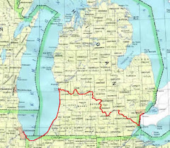
I have had difficulty trying to sort out the various Newsletter entries by Verlen, Valerie, Valerie's brother Jon who constituted the land team, and the Editor in order to follow their route after Marquette. Valerie's is the most helpful.
 
Valerie: "When we arrived in Au Train, to paddle south through the Upper peninsula, we found the river frozen. The basin was a sheet of ice and the Whitefish was frozen into Little Bay de Noc...With the assistance of Jack McHugh, we portaged the iced-in portion of our route and put our canoes into Little Bay de Noc".  I take that to mean they put their canoes on McHugh's truck at the Lake Superior shore at Au Train and rode across the UP to somewhere above Gladstone where they found open water. 
 
Valerie continues: "As we paddled into Lake Michigan on November 15  I wondered if we had made a mistake even considering to continue our expedition. Little Bay de Noc was frozen several hundred feet from shore, making landing impossible...One of the turning points  of our journey came when we landed near Stonington. We were paddling into Big Bay de Noc, and, as we had hoped, there was no ice formed on th exposed shore."  Next morning the snow stopped and they were able to paddle on to Manistique Harbor. The harbor froze over that night so they had to use Verlen's Sea Wind as an ice-breaker to get out to to Lake Michigan in the morning.
 
Valerie again: "We did continue - across the Straits of Mackinac, into Lake Huron, down the eastern shore of Lower Michigan, past Rogers City, Alpena, Harrisville and Oscoda before we were stopped again, waiting on weather to make the crossing of Saginaw Bay." Because they had schedule commitments they couldn't wait so they portaged around Saginaw Bay to Harbor Beach. She didn't say how. There they resumed paddling. "At Port Sanilac, we came ashore just at dark. We had paddled 30 miles since dawn and had to break ice from our spray covers to climb onto the public dock..."
 
They continued south, paddling each day and making presentations each night at towns along the shore including Port Huron and Detroit, where they stayed several days before continuing on to Lake Erie, the Maumee and the portage to the Wabash and points south that I have already covered.
 
I am now going to go back to Marquette and mount my virtual helicopter and follow their path to Detroit where I started out following them in the first message in this series. This will be the last as I don't intend to follow them to Florida, the Caribbean or South America. If someone else  would take on that chore I would be most pleased.
 
This has been an effort in memory of Verlen and in support of Valerie in her fight for life.

Tuesday, February 16, 2010

Following Verlen and Valerie-XVIII-Paddling the Great Lakes in Winter


In their Newsletters Verlen and Valerie skipped straight from Grand Portage, Minnesota, to their first Michigan landfall at Black River Harbor. I decided I shouldn't do that so I took to my virtual helicopter and followed their path along Lake Superior's Minnesota and Wisconsin shores until I caught up with them. Their strategy for paddling the Great Lakes as set out by Verlen was to average about 32 miles a day, sit out windy days, and paddle the miles very carefully "...with one foot on the shore..." 
 
The Newsletter Editor, Dorothy Webster, filled in some detail: "...after two days spent refitting at Grand Marais, Minnesota, the big lake began acting like an ocean and tossed Verlen and Valerie around on giant waves. Val, who didn't take all her seasickness medicine, was more than queasy..."
 
I put Google Maps Satellite on the screen and carefully followed the Minnesota shore southwesterly to the twin cities of Duluth and Superior, then went easterly and northeasterly along the Wisconsin shore and through the Apostle Islands and arrived at Michigan just where the Montreal River enters the Big Lake. Then a few miles further is Black River Harbor.
 
Valerie: "Landfall in Michigan was something to celebrate. We arrived just before dark, paddling into the shelter of the slag breakwall...We were windbound three days at Black River Harbor. Little did we know that we had just began our struggle. Getting to Michigan turned out to be the easy part". She tells of stops in Ontanogan and Houghton-Hancock where they were windbound for several days.
 
 She goes on: " When paddling was possible again, it was also unusually difficult. The cold temperatures of the early onset of winter caused each wave and splash to freeze on our canoes. Sitting on the waterline we became human ice chunks, and within a few hours of paddling each day, we were literally frozen into our canoes by the ice build-up on our spray covers...My paddle shaft was coated with ice. The bow line was glued to the gunwale...My gloves got so stiff from the ice they became immovable..."
 
Following the Krugers along the Lake Superior shore from Black River Harbor to the Portage Lake Ship Canal on the Keweenaw Peninsula brought on another nostalgia attack. As I flew over the mouth of the Presque Isle River and along the Porcupine Mountains I was reminded of backpacking trips in the "Porkies" with my late brother Dick and his daughters. Over Silver City I was reminded of another of life's great beers in the sole local tavern at the thirsty end of one of those trips. Sighting McLain State Park by the entrance to the canal I remembered camping in my Jayco pop-up trailer with Dick during a geological field trip, the last time he and I ever camped out together.
 
Jack McHugh of Escanaba paddled with the Krugers as they crossed Keweenaw Bay from Portage Entry: "Before we left the protection of the canal the Krugers linked their boats into a catamaran arrangement with two stout cross poles. Tremendous initial stability is thus attained...I did not have this advantage but felt confident as long as the seas did not become mountainous...We moved into the swell and chop of an icy Keweenaw Bay, being conservative and heading southeast so crossing the shortest distance..." He goes on for about six paragraphs on the awful wind, wave and ice conditions of that crossing. "Eventually a difficult landing was made on a steep, wave swept, rocky shore...the three of us resembled abominable snow men, with icicles hanging everywhere..." He allowed as how he was not anxious to make any similar crossings.
 
I find no words from either Kruger covering their adventures from that landing until they arrive at the Au Train River. Thus no description of their travels along the Huron Mountain shoreline which is absolute wilderness most of the way. They would certainly have stopped at Big Bay where "Anatomy of a Murder" was filmed. They would have rounded Presque Isle Park on their way into Marquette.
 
Editor Webster describes their arrival in Marquette: "The paddlers rounded the breakwall next to the Marquette Lighthouse and paddled the 600 to 700 yards to a sandy beach near the US Coast Guard boathouse. It seemed to take them forever. Small whitecaps broke the lake's surface and the spray formed a thin film of ice over the paddlers, their canoes and their clothing. Beaching the canoes was difficult - no one wanted to get wet feet in those conditions - so the paddlers backed off, gathered up steam and paddled those craft right onto the beach with a mighty effort. Everybody cheered!"
 
NEXT: Lake Michigan and Lake Huron.

Thursday, February 11, 2010

Following Verlen and Valerie-XVII-Through the Boundary Waters to Lake Superior


The Newsletters don't reveal much about Verlen and Valerie's trip through the Boundary Waters. Verlen had been in the Boundary Waters several times, canoe racing and on his 1971 trip and again in 1983 with Valerie.

In One Incredible Journey Verlen and author Clayton Klein devote an 18 page chapter to the 1971 tandem canoe trip up the Boundary Waters and Rainy Lake with Clint Waddell.

In 1983 on the Ultimate Canoe Challenge homeward bound part of the trip Valerie rejoined Verlen in North Dakota and stuck with him through the Boundary Waters and Grand Portage to Lake Superior. Then she returned to Seattle and Verlen went home to Jenny.

In The Ultimate Canoe Challenge Verlen describes their trip through the Boundary Waters in 1983. I assume the same description would fit their 1986 journey:

"The Border Route is historic canoe country. We were now paddling in the shadow of hundreds of years of French-Canadian voyageurs and thousands of years of Indian canoeists...We went up through the big border lakes - Rainy, Kabetogama, Namakan, Sand point, La la Croix, Crooked, Basswood, Knife, Sagana, Gunflint. This was the BWCA-Quetico country, familiar not only from history, but from the thousands of canoeists who travel these waters each summer. I had paddled there many times and knew it well...Most of the paddling was flat water with some short, challenging portages...wherever possible we paddled up rapids or lined the boats through, but some portages could not be avoided...by that evening we had covered 32 miles and had crossed 11 portages to a camp on Knife Lake.

In the next few days we passed the Height of Land between South and North Lakes, then paddled down the lakes and Pigeon River to the Grand Portage. Here the voyageurs cut cross-country to avoid the last miles of the Pigeon River, which are steep and violent and have several waterfalls, including 120-foot Pigeon Falls."
I imagine they used the Ralph Freese furnished canoe wheels on the Grand Portage. In One Incredible Journey Verlen describes the Grand Portage: "The Grand Portage Trail itself is a big, open and well maintained path that you could drive a Jeep down. It appeared to be used frequently by backpackers or hikers, but seldom does any one carry a canoe down it."

I took my time and used the seagull approach and thoroughly covered various routes between Rainy Lake and Lake Superior. I even went backwards up much of our 1948 Turtle River route and back down.

Next: Wintertime Paddling on the Big Lakes

Tuesday, February 2, 2010

Following Verlen and Valerie-XVI-Lake Winnipeg and Beyond


Neither Verlen nor Valerie described their trip from the Churchill River through Frog Portage and the Sturgeon-Weir River and lake system to the town of The Pas. I looked at the chore of trying to describe it by working backwards through the descriptions in One Incredible Journey for the 1971 trip or The Ultimate Canoe Challenge for the 1981 trip but since I am only following them, not trying to tell their story, I decided just describe their route as shown on the 1971 trip map and take to my virtual helicopter.
 
The map shows in order from north to south Frog Portage (Verlen said it had a good trail), Lindstrom Lake (text) or Manawan Lake (map)?, Wood Lake, Pelican Narrows, Mirond Lake, the Sturgeon-Weir River, Amisk Lake, more river then Sturgeon Landing on Cumberland Lake, the lake and then the river to its confluence with the Saskatchewan River. Time out while I fly their route to The Pas...
 
Verlen in Newsletter Number 6 December 1986: "Early in the morning of September 9, we departed The Pas, Manitoba, paddling side by side in our solo Sea Wind canoes down the Saskatchewan River...We enjoyed the novelty of downstream paddling for the next one and one half days knowing that it would be the last until we reached the Wabash River at Fort Wayne, Indiana...(maybe wrong, as I will demonstrate later)  It may sound strange but in the first six months and 5,000 miles, we have paddled less than 300 miles downstream.
 
The Saskatchewan River widens out into Cedar Lake and Cross Lake. It is about 100 miles across these lakes. They are the backwater of a huge dam at Grand Rapids, Manitoba. Here the water spills into Lake Winnipeg and flows out the north end to go down the Nelson River to Hudson Bay. But we went the other way. It took us 10 1/2 days to go nearly 300 miles across Lake Winnipeg to the Winnipeg River.
 
On September 24 we started up the Winnipeg River. There are eight dams in the 180 miles from Lake Winnipeg to Kewatin. It is beautiful canoe country. There is a government boat lift into Lake of the Woods at Kewatin but it was closed. Lake of the Woods, with its thousands of islands and 80 miles across would be an easy place to get lost. To complicate matters we had a heavy fog all one morning. We watched our compass very closely and had no problems......we started up the Rainy River...it was high this year. We had to line our canoes about 50-feet around he main drop on Lone Rapids and make a short portage on the right at Manitou Falls." They are now in Rainy Lake.
 
I am starting to get nostalgic as I tap out these words for the Krugers are about to paddle the exact same waters (if not the same water) that my brother John and two fraternity brothers from the Colorado School of Mines paddled in two 18' wood and canvas canoes 38 years earlier. It was 1948, 15 years before Verlen even paddled a canoe for the first time. 
 
The Krugers are paddling down Rainy Lake to the twin cities of Fort Francis, Ontario, and International Falls, Minnesota. We paddled up Rainy Lake but instead of going into the Rainy River we headed north upstream through a series of lakes and straits and rapids for two weeks to a five mile portage over the Height of Land. Sounds just like what the Krugers had been doing. They lined up a rapids and portaged another to get into Rainy Lake and we waded our canoes up a rapids to get out of Rainy Lake.
 
I decided it was time to enlist my seagull system and follow our 1948 canoe trip in memory of brother John and Ken Matheson, who have been gone for many years, and in honor of Ned Wood who sends me political and patriotic Emails every so often and an annual Christmas letter about his 9 kids and their families.
 
I used Digital-Topo-Maps.Com and followed up Rainy Lake to the Manitou River system of rivers, lakes, straits, rapids and portages to the ghost town of Gold Rock at the head of a 5 mile portage across the Height-of-Land. Things have changed in 62 years but it is still almost all wilderness. There is a marina at the rapids where we first had to portage and roads cross our our route in a couple of places. Gold Rock still looks abandoned. Lake Wabigoon leading up to Highway 17, the Trans-Canada Highway, still looks wild.
 
 I think I spotted what we named "Slimey Island", a wet, rocky, inferior campsite in Lake Wabigoon to which we returned all beered up after an afternoon at an Official Province of Ontario "Purveyor of Beer" by a Hudson's Bay Store in the hamlet of Dinorwic on Highway 17.
 
I then seagulled upstream over the Wabigoon River to the portages to Long Lake and the Turtle River, which in 1948 we followed all the way back to Rainy Lake, shooting rapids (no PFDs) and portaging around falls. In the process I crossed roads that weren't there in 1948.
 
Although I choked up a couple of times, I'm glad I did it.
 
Next: Through the Boundary Waters to Lake Superior.