Friday night I enjoyed the hospitality of daughter and son-in-law's friends John Schneider and Sharon Emery at their Lake Huron cottage, so often mentioned in John's column in the Lansing State Journal (I am a faithful reader). They are responsible for Ken and Karen having a cottage on Black Lake (long story). Their friend (and Sharon's former work colleague) Meegan Holland took the long way to Cheboygan but made it in time for a delicious meal featuring Lake Huron-caught (by John) Chinook salmon. An interesting bunch and a marvelous evening all around.

Sunday, August 16, 2009
Great evening on Lake Huron at the Schneider Cottage
Friday night I enjoyed the hospitality of daughter and son-in-law's friends John Schneider and Sharon Emery at their Lake Huron cottage, so often mentioned in John's column in the Lansing State Journal (I am a faithful reader). They are responsible for Ken and Karen having a cottage on Black Lake (long story). Their friend (and Sharon's former work colleague) Meegan Holland took the long way to Cheboygan but made it in time for a delicious meal featuring Lake Huron-caught (by John) Chinook salmon. An interesting bunch and a marvelous evening all around.
Wednesday, August 12, 2009
Further revision of LaSalle's route? Another exercise in topology*
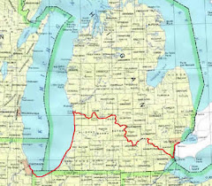
In my June 14 2009 Email "Revise LaSalle's Route? An Exercise in Topology" I discussed the new "tools" that have become available since I did my original research including Internet access, satellite imagery and the Natural Features Inventory pre-settlement vegetation maps.
In that memorandum I described what I believe to be a more accurate designation of the LaSalle party's probable route from where they abandoned their elm-bark canoe along side the Huron River to where they built the raft to float across the Detroit River.
In this exercise I am re-looking at how they got from Ft. Miami to the Paw Paw River valley on the first day of their cross-peninsula trek on March 24, 1680.
Those of you who know the Twin Cities know that downtown St. Joe where Ft. Miami was located sits on top of a very steep bluff overlooking the St. Joseph River on the north and Lake Michigan's beach on the west. Now the river is confined by Corps of Engineers' breakwaters to a straight west course out into the lake. In LaSalle's time it was free-flowing and curved around the base of the bluff a ways before entering the lake. The actual entrance shifted north or south over time according to the whims of storms and the along-shore current.
The Paw Paw River flows into the St. Joseph River from the northeast through an extensive low-land which in LaSalle's day was a large marsh. The extent of that marsh is shown very plainly on the pre-settlement vegetation map of Berrien County. The confluence of the Paw Paw with the St. Joseph is about 3/4 mile east of and inland from the Lake Michigan shore. The marsh extended most of that distance. There were low sand dunes between the marsh and the big lake.
The high and dry ground on both sides of the St. Joseph River was covered with a beech-sugar maple forest according to the pre-settlement vegetation map as was the dry land south of the Paw Paw River marsh now occupied by the City of Benton Harbor.
When LaSalle concluded that his ship the Griffon was lost and that he would have to return to Niagara by walking cross-country his first problem was getting across the St. Joseph River. They had walked up the Lake Michigan beach from the south and climbed the bluff to get to the fort. I am surprised that the two men occupying the fort didn't have a canoe but apparently not because LaSalle's party built a raft to cross the St. Joseph. LaSalle said that took them half a day on March 24, 1680.
My first job in this exercise is to figure out where they would have been able to cobble together a raft. It makes sense that it would have been on the left bank of the St. Joseph where there was relatively level, dry ground (as opposed to where the river flowed against the steep bluff or marshland) and where the river bank was covered by trees. This assumes that LaSalle and his men would have made their raft by lashing together riverside downed trees or large branches with vines.
A close examination of the pre-settlement vegetation map and the USGS Benton Harbor Quadrangle topographic map (1:24,000 1970) shows that the closest such place to the fort would have been along the left bank of the river a little less than a half mile downstream of the Napier Avenue Bridge (Napier Avenue follows the trace of an old Indian trail that eventually led to the Kalamazoo River ford). That location would have been about 1 3/4 miles from the fort. The route from the Ft. Miami Historical Marker would be kitty-corner south to the intersection of Wayne and Broad Streets then down Broad Street (past the house where my late wife Elaine grew up) to the bottom of the hill and then following Ann Street upstream along the river bank.
The next question becomes would they have crossed the river directly or would they have floated downstream before they landed and got off the raft on the right bank? If they could have floated or poled about 3/4 mile downstream they could have landed on a prominent point just beyond a gully cut in the right bank by an intermittent stream. They would have run into some marsh before they could reach the bank at that point but in spring flood the water level would probably have been high enough. Today Parker Avenue comes down to the river at that point, about a block south of Benton Harbor High School.
That side of the St. Joseph River was also covered with beech-maple forest. About a mile to two miles to the east began more open oak-hickory forest. LaSalle was deliberately avoiding Indian trails and open woods, savannas or prairies for fear of Iroquois war parties so he would have headed northeast along the edge of the Paw Paw River marsh still in the beech-maple woods until the marsh ran out where the Paw Paw flowed out of a relatively narrow valley.
To follow that route today you would zigzag through Benton Harbor on Empire Avenue, Colfax Avenue, East Market Street, Highland Avenue, Paw Paw Avenue and Territorial Road.
The area where LaSalle and his men would have started up the Paw Paw River valley is now mostly occupied by the Southwest Michigan Regional Airport.
The pre-settlement Paw Paw River marsh was over two square miles in area. It's extent can be plainly seen on a topographic map or by observation from high ground in St. Joe or Benton Harbor.
The vegetation type of the Paw Paw River valley bottom was (and mostly still is) mixed hardwood swamp. I believe the travelers would have been following the edge of the beech maple forest above the mixed hardwood swamp. Remember they were traveling in the leafless season thus would have been able to hike along away from the river a ways just keeping the left bank of the meanders in view without having to follow closely the Paw Paw's extremely sinuous path.
The problem of trespass on private land keeps us from laying out a trail closely following LaSalle's but there are places where the 1680 experience can be sampled such as the Sarrett Nature Center between Benton Harbor and Coloma, adjacent to the Watervliet Airport runways, and the Southwest Michigan Land Conservancy's Paw Paw River Preserve.
* In case you have forgotten or never knew, "topology" is defined as the topographic study of an area in relation to its history.
Saturday, August 8, 2009
LaSalle Relay Inaugural - Second Leg
Son Jim took advantage of another of his unpaid State Worker furlough days to bicycle another leg of the LaSalle Relay St. Joe-to-Detroit River cross-peninsula route. You will remember that on July 24 he and fellow State Worker Dale Turton bicycled the route from St. Joe to Kalamazoo. I reported on that trip by Email of July 28.
This time on Friday August 7 he started at Springport and bicycled to the Waterloo Farm Museum. His route took him through Tomkins Center, Rives Junction, Pleasant Lake and Munith. He crossed the Grand River on the Maple Grove Road bridge. I volunteered to drive "Sag Wagon" for him and caught up with him in my Chevy Malibu Maxx at Munith and then waited for him at the Farm Museum.
Before heading back to his bicycle-carrying Pontiac Vibe parked at the Springport High School we toured the Portage Lake Swamp and Hugh Heward portage territory crossed by Charlie Parmelee and Doug McDougall in 2008; walked, waded and back-portaged by Neil Miller and Brian Prodin on April 17 of this year, and portaged with wheels by the Ultimate Hugh Heward Challenge paddlers this last spring. We were really impressed by the difficulties of terrain and distances covered by these guys in 2008 and 2009 and by Hugh and his Frenchmen in 1790.
On the return trip we took an alternate route and made the Berry Road Bridge crossing of the Grand. You may remember that I believe the LaSalle party's 1680 encounter with the Mascoutin Indians (who mistook them for an Iroquois war party) took place at the Grand River crossing between the Maple Grove Bridge and the Berry Road Bridge.
The Jackson County roads were uniformly good to excellent for bicycling in contrast to Calhoun County's poor roads that we had explored by car earlier. The scenery and terrain are very attractive.
On a trip to Ron Sell's Unadilla Boat Works earlier in the summer for Jim to try out a Bell Rob Roy solo canoe we explored the route LaSalle had walked from the site of today's Waterloo Farm Museum to the Huron River at Dexter. Island Lake Road, which follows the old Indian trail, is very rough and unsuitable for bicycles as are most of the roads leading to it. Our tentative plans for next year's LaSalle Relay call for this 6 1/2 mile stretch to be hiked. If we go for bicycling beyond the Farm Museum we will have to work out an alternative route.
Jim is hoping for opportunities to bicycle the gap between Kalamazoo and Springport before he goes on the Dalmac Lansing-to-Mackinack bike tour on Labor Day weekend. We have not yet reconnoitered the roads between Kalamazoo and Pennfirld in Calhoun County by car.
Subscribe to:
Posts (Atom)