Since I did my research on the route of LaSalle's 1680 walk across the Lower Peninsula in the 90's many additional tools have become available to me. Some are technical like my kids' hand-me-down computers which have given me access to the magic of Internet mapping sites.
Others are newly published like the Natural Features Inventory pre-settlement vegetation maps for all Michigan counties.
Still others existed before but I had only limited access to them. I'm thinking of Hinsdale's 1931 "Archaeological Atlas of Michigan", for example. When I was doing my research in the Library of Michigan I could access that large atlas a couple hours at a time at most, and then only on those occasions that I was able to neglect other duties to spend time in the library. Now, thanks to the generosity of Karl Williams, I have my own photographic copy of Hinsdale for the counties I am working on.
Also thanks to Karl and Geneva Wiskemann I have color copies of the pre-settlement vegetation maps of those counties. And thanks to Jean King for her penetrating questions that send me back to the drawing board to justify some of my conclusions. Karl has also pushed my button by sending photographic copies maps showing old Michigan pioneer trails for me to study. These "old timers" (I can call them that, being older than they) are keeping me on my toes.
Enough of the cliches and thanks. Now to what I have set out to do, review and if necessary revise my conclusions from the 90's as to the route of LaSalle's cross-peninsula walk.
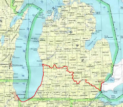
I remain satisfied as to the route I think that LaSalle and his men took in 1680 from his fort at today's city of St. Joseph on Lake Michigan nearly to the upper end of the Portage River in the northeast corner of Jackson County.
As I said in my May 25 message "LaSalle Relay-The "Corridor", if I could redo the map with the 1999 Michigan History article and the enlargement that hangs in the Michigan Historical Museum I would move the red line showing his route to take him north of the upper end of the Portage River (see my blog www.thetopologist.blogspot.com).
I am no longer happy with the route I showed the party using when walking to the Detroit River after they gave up trying to go down the Huron and abandoned thier elm-bark canoe. Here is my new take:
I still think they left the Huron at French Landing where the river takes its big bend to the south. I think they then followed an Indian trail that Hinsdale shows and calls the "Potawatomi Trail". This trail generally follows the trend of the Huron between its left bank and a couple of tributaries named Silver Creek and Smith Creek. It does not follow all of the Huron's meanders.
Hinsdale shows another Indian trail paralleling the Lake Erie shore and the right bank of the Detroit River. That trail is now traced by a highway called River Road on some maps and West Jefferson Avenue on others. It was the main Indian trail between the mouth of the Maumee River (Toledo) and present-day Detroit.
Between that trail and Lake Erie the pre-settlement vegetation map shows nothing but marsh to the south and for a long ways to the north. Hinsdale's Potawatomi Trail dead ends at that unnamed trail. I think LaSalle and his men would have turned left and followed the shore trail to the northeast for two reasons. First it would have been obvious from that location that to the south the marsh around the mouth of the Huron was very extensive. Second, they wanted to end up at the bank of the Detroit River, not the shore of Lake Erie.
Following the shore trail in a northerly direction they would have had marsh to their right between them and the river until they arrived at the peninsula now occupied by Gibralter. The pre-settlement vegetation map shows woods right up to the river bank there. They needed live and dead elm trees and materials to make a raft. LaSalle 's plan called for leaving two men to make an elm-bark canoe and go to Michilimackinac, while the remaining four would build a raft and cross the Detroit River to present-day Ontario.
I believe the raft would have been made from riverside downed trees and large branches lashed together with vines. Starting the river crossing at the Gibralter peninsula would have them launching in the shelter of the peninsula and Celeron Island and would give them room to diagonal towards the Ontario shore and land before they could be swept into Lake Erie by the river's current.
I think you who are interested can follow all this on your maps, but we really need to make one for the blog. I'll consult with my daughter the Blogmaster on that.

Sunday, June 14, 2009
Subscribe to:
Post Comments (Atom)
No comments:
Post a Comment